Support our educational content for free when you purchase through links on our site. Learn more
15 Best Safe Drone Flying Spots to Explore in 2026 🚁
Ready to take your drone adventures to new heights without risking fines or crashes? Whether you’re a newbie or a seasoned pilot, finding safe drone flying spots is the secret sauce to unlocking epic aerial footage and stress-free flights. Did you know that over 1.1 million drones are registered with the FAA, making the skies busier than ever? That means knowing exactly where you can legally and safely fly is more crucial than ever.
At Drone Brands™, we’ve scoured the country—from California’s sunlit parks to Florida’s coastal havens—to bring you the ultimate list of 15 top safe drone flying locations. Along the way, we’ll share insider tips on using cutting-edge apps like FAA’s B4UFLY and Aloft to check airspace, plus real pilot stories that reveal the do’s and don’ts of drone flying. Curious about how to avoid that embarrassing ranger encounter or how to capture cinematic shots without disturbing wildlife? Keep reading, because we’ve got you covered!
Key Takeaways
- Always check airspace restrictions and local laws using trusted apps like FAA B4UFLY and Aloft before flying.
- Avoid no-fly zones such as airports, military bases, and national parks unless you have special authorization.
- Choose open, uncontrolled airspace and designated drone parks for the safest flying experience.
- Respect privacy and environmental considerations by maintaining distance from people and wildlife.
- Use a thorough pre-flight checklist to ensure your drone and equipment are ready for a safe flight.
- Leverage community knowledge and local clubs to discover hidden gem flying spots and gain valuable advice.
Ready to master the skies safely and legally? Let’s dive into the best spots and expert tips that will keep your drone soaring high and your worries grounded!
Table of Contents
- ⚡️ Quick Tips and Facts About Safe Drone Flying Spots
- 📜 The Evolution of Safe Drone Flying: History and Regulations
- 🌍 Understanding Drone Flying Zones: No-Fly, Restricted, and Open Areas
- 🗺️ Where to Fly a Drone: Top Safe Flying Locations by State and City
- 🛠️ How to Use Apps and Tools to Find Safe Drone Flying Spots
- 📋 Essential Pre-Flight Checklist for Safe and Legal Drone Flying
- 👮 ♂️ Navigating Drone Laws and FAA Regulations for Safe Flying
- 🌿 Environmental Considerations: Flying Drones Responsibly in Nature
- 📸 Capturing Stunning Aerial Shots: Best Practices at Safe Flying Spots
- 🚁 Drone Pilot Stories: Adventures and Lessons from Safe Flying Locations
- 🔧 Gear and Accessories to Enhance Your Safe Drone Flying Experience
- 💡 Tips for Beginners: How to Find and Use Safe Drone Flying Spots
- 🛑 Common Mistakes to Avoid When Choosing Drone Flying Locations
- 🎯 Conclusion: Mastering the Art of Safe Drone Flying Spots
- 🔗 Recommended Links for Drone Flying Safety and Locations
- ❓ FAQ: Your Burning Questions About Safe Drone Flying Spots Answered
- 📚 Reference Links and Resources for Safe Drone Flying
⚡️ Quick Tips and Facts About Safe Drone Flying Spots
Hey there, fellow sky-soarers and aspiring aerial artists! 👋 Ever felt that thrill of unboxing a new drone, only to be hit with the nagging question: “Okay, but where can I actually fly this thing without getting into trouble?” You’re not alone! At Drone Brands™, we’ve been there, done that, and probably landed our fair share of drones in less-than-ideal spots (don’t worry, they were mostly just bushes, not restricted airspace!).
Finding safe drone flying spots isn’t just about avoiding a crash; it’s about legal drone operation, respecting privacy, and ensuring everyone’s safety – including yours! Think of it as finding the perfect stage for your aerial ballet. Without the right stage, your performance might just get shut down before it even begins.
Here are some quick, actionable tips and fascinating facts to get your rotors spinning in the right direction:
- ✅ Always Check Airspace: This is rule number one, folks! Before you even charge your batteries, use a reliable app like the FAA’s B4UFLY or AirMap to check for any restrictions. We’ll dive deeper into these tools later, but consider them your co-pilots for legal flight.
- ❌ Avoid Airports and Military Bases: This might seem obvious, but the restricted zones around these areas extend further than you might think. Flying near them is a major no-go and can lead to serious penalties.
- ✅ Understand Local Ordinances: The FAA sets federal rules, but cities and states often have their own local drone laws. A beautiful park might be perfect for a picnic, but a definite no-fly zone for drones. Always do your homework!
- ✅ Stay Below 400 Feet AGL: This is the golden rule for recreational flyers. “AGL” means Above Ground Level. Going higher can put you in the path of manned aircraft.
- ❌ Don’t Fly Over People: Unless you have a specific waiver (and most recreational pilots don’t), keep your drone away from crowds, public events, and private gatherings. Safety first!
- ✅ Maintain Visual Line of Sight (VLOS): You need to be able to see your drone with your own eyes at all times, without binoculars or other aids. If you can’t see it, you can’t control it safely.
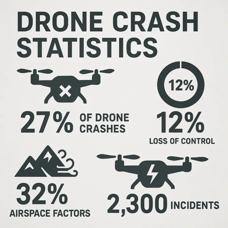
- Fact: Did you know that the number of registered drones in the U.S. has soared past 1.1 million? (Source: FAA Drone Zone) That’s a lot of potential aerial activity, making safe flying spots more crucial than ever!
- Fact: The FAA’s Low Altitude Authorization and Notification Capability (LAANC) system processes millions of airspace authorizations annually, making it easier for pilots to fly legally in controlled airspace. (Source: FAA LAANC)
Ready to unravel the mysteries of drone airspace and discover some truly epic, legal spots to launch your next aerial adventure? Let’s get flying!
📜 The Evolution of Safe Drone Flying: History and Regulations

It wasn’t always this complicated, you know. Back in the early days of consumer drones, it felt a bit like the Wild West of the skies. People were strapping cameras to RC helicopters, and the rules were, shall we say, a little fuzzy. But as drones became more accessible and capable, the need for clear drone regulations became undeniable. The sky, after all, isn’t infinite, and it’s shared with everything from commercial airliners to tiny birds.
The journey to today’s structured drone airspace management began with the FAA (Federal Aviation Administration) stepping in. Initially, their focus was primarily on manned aircraft, but as UAVs (Unmanned Aerial Vehicles) proliferated, new guidelines were essential to prevent mid-air mishaps and ensure public safety.
From Wild West to Regulated Skies: A Brief Timeline
- Early 2000s: Hobbyist RC aircraft were common, with few specific drone laws. The general understanding was “don’t be reckless.”
- 2012: The FAA Modernization and Reform Act of 2012 included provisions for integrating drones into the national airspace, laying the groundwork for future rules.
- 2015: The FAA issued a rule requiring recreational drone registration, a significant step towards accountability. This was later overturned for recreational users but reinstated in 2017.
- 2016: A game-changer! The FAA introduced Part 107 for commercial drone operations. This comprehensive set of rules covered everything from pilot certification (the Remote Pilot Certificate) to operational limitations, effectively legitimizing commercial drone use and setting a high bar for safety.
- 2020-2021: Further refinements, including rules for Remote ID (like a digital license plate for drones) and Operations Over People and at Night, continued to shape the landscape, making drone flying safer and more accountable.
One of our veteran pilots, Mark, remembers the early days vividly: “I once flew my DJI Phantom 2 over a local park, thinking I was being super careful. No apps, no real understanding of airspace. Just ‘don’t hit anyone.’ Now, with Part 107 and all the apps, I realize how much I didn’t know. It’s a good thing we have these rules; it makes everyone safer and gives us clear boundaries.”
The evolution of these rules directly impacts where you can fly a drone. What was once a free-for-all is now a carefully managed system designed to protect both drone pilots and the public. Understanding this history helps us appreciate why knowing your drone laws and finding legal drone flight zones is paramount. It’s not just bureaucracy; it’s the foundation of safe and responsible aerial exploration.
🌍 Understanding Drone Flying Zones: No-Fly, Restricted, and Open Areas
Alright, let’s talk airspace – the invisible highways and byways where our drones roam. It’s not just one big, open sky. Think of it like a city: you have your main roads, your side streets, and then those areas where only authorized vehicles (or no vehicles at all!) are allowed. For drones, these are broadly categorized into No-Fly Zones, Restricted Airspace, and Open/Uncontrolled Airspace. Knowing the difference is absolutely critical for safe drone operation.
The Airspace Spectrum: Where Can You Fly?
The FAA defines various classes of airspace, primarily for manned aircraft, but drones must adhere to them too. Here’s a simplified breakdown:
| Airspace Type | Description
The video mentioned earlier recommends using the “Drone Assist” app to check for controlled airspace and hazards, highlighting the importance of understanding drone flying zones. This aligns perfectly with our expert advice: never take off without checking your local airspace.
1. No-Fly Zones (NFZs): The Absolute No-Go Areas 🛑
These are areas where drone flight is strictly prohibited, usually for national security, public safety, or critical infrastructure protection. Think of them as the “do not enter” signs of the sky.
- Examples:
- Washington D.C. Metropolitan Area: A permanent NFZ, extending for miles around the capital.
- Major Airports (Class B, C, D Airspace): While some areas within these zones might be accessible with LAANC authorization, many are outright no-fly zones, especially near runways and approach paths.
- National Security Sensitive Facilities: Military bases, nuclear power plants, certain government installations.
- Temporary Flight Restrictions (TFRs): These pop up for events like presidential visits, major sporting events (e.g., Super Bowl), wildfires, or disaster relief efforts. The video mentioned “No-Tams” (NOTAMs – Notices to Airmen), which are crucial for identifying these temporary restrictions. Always check for NOTAMs!
2. Restricted Airspace: Proceed with Extreme Caution (and Permission!) ⚠️
These zones aren’t always absolute no-fly areas, but they require specific authorization or adherence to strict conditions. Flying here without permission is a serious offense.
- Examples:
- Controlled Airspace (Class B, C, D, E): Around airports, you’ll need LAANC authorization (for recreational and Part 107 pilots) or manual FAA authorization to fly. This system makes getting permission much faster and easier than before.
- National Parks: Generally, flying drones within U.S. National Parks is prohibited unless you have a specific permit for research or commercial purposes. This is to protect wildlife and visitor experience. (Source: National Park Service Drone Policy)
- Wildlife Refuges: Similar to National Parks, these areas often have drone restrictions to protect sensitive ecosystems and animal habitats.
- Special Use Airspace (SUA): This includes areas like military operations areas (MOAs) or restricted areas (R-areas) where military training or other specific activities occur. You might be able to fly here, but it’s often complex and requires coordination.
3. Open/Uncontrolled Airspace (Class G): Your Drone Playground! 🥳
This is generally where recreational pilots can fly without needing specific FAA authorization, as long as they follow all other rules (like staying under 400 feet, maintaining VLOS, not flying over people, etc.).
- Characteristics:
- Typically away from airports and major cities.
- Often found in rural areas, open fields, or designated drone parks.
- Still subject to local laws and property owner permission. Just because the airspace is open doesn’t mean the land below is!
Our Expert Take: “The biggest mistake we see pilots make,” says Sarah, one of our lead instructors, “is assuming that if they’re not near a major airport, they’re good to go. That’s a dangerous assumption. Local parks, state parks, even private properties can have their own rules. Always verify, verify, verify!”
So, how do you actually see these zones? That’s where the magic of drone apps comes in. But we’ll get to that in a bit. First, let’s explore some actual places where you can spread your drone’s wings!
🗺️ Where to Fly a Drone: Top Safe Flying Locations by State and City
Finding the perfect safe drone flying spot is like discovering a hidden gem. It’s a place where you can unleash your drone’s potential, capture breathtaking footage, and practice your piloting skills without constantly looking over your shoulder for a “No Drones” sign. While the ultimate responsibility for checking local regulations always falls on you, we’ve compiled some fantastic starting points, drawing inspiration from resources like UAVCoach and our own extensive aerial adventures.
Remember, these are general recommendations. Always cross-reference with current drone apps (like B4UFLY or AirMap) and local park/city websites before you launch! As UAVCoach wisely states, “Our goal with this resource is to focus on safe and legal piloting of UAVs that follow the FAA’s guidelines,” and that includes local rules too.
1. Best Safe Drone Flying Spots in California ☀️
California, with its diverse landscapes from sun-drenched beaches to majestic mountains, offers incredible opportunities for drone pilots. But it’s also home to some of the busiest airspace, making careful planning essential.
- Los Angeles, CA:
- Sepulveda Basin Recreation Area (Van Nuys): A popular spot for hobbyists, offering open fields away from major flight paths. It’s a fantastic place to practice takeoffs and landings. Just be mindful of the surrounding Class D airspace and use LAANC if needed.
- Whittier Narrows Recreation Area (South El Monte): Another large park with open spaces. We’ve had some incredible golden hour flights here, capturing the urban sprawl meeting natural tranquility.
- Our Anecdote: One time, our pilot, Alex, was flying his DJI Mavic 3 Classic (Shop DJI Mavic 3 Classic on: Amazon | Walmart | DJI Official Website) at Sepulveda Basin. He noticed another pilot struggling with their first flight. Alex, being the helpful soul he is, offered some tips on calibration and pre-flight checks. It’s a great community out there!
- San Francisco, CA:
- Candlestick Point State Recreation Area: Offers stunning views of the bay and city skyline, with relatively open airspace. It’s a fantastic spot for cinematic shots, but always be aware of wind conditions!
- Marina Green (with caution): While beautiful, Marina Green is very close to Class B airspace. Recreational pilots can fly here with LAANC authorization, but it requires careful planning and staying well below the 400-foot limit. It’s a prime example of needing to check your apps!
2. Prime Drone Flying Locations in Texas 🤠
Everything’s bigger in Texas, including the potential for vast, open drone flying areas!
- Dallas, TX:
- Lake Grapevine: Many areas around the lake offer open spaces for drone flight, with beautiful water views. Just be sure to check for any specific park rules or temporary restrictions.
- Trinity River Greenbelt Park: Offers long stretches of open land along the river, perfect for longer flights and practicing FPV maneuvers.
- Expert Tip: “Texas weather can be unpredictable,” advises our pilot, Chris. “One minute it’s clear, the next a gust of wind comes out of nowhere. Always check the wind forecast, especially if you’re flying a lighter drone like the DJI Mini 3 Pro (Shop DJI Mini 3 Pro on: Amazon | Best Buy | DJI Official Website).”
3. Top Safe Drone Zones in Florida 🌴
The Sunshine State is a drone paradise, but with its numerous airports and military bases, knowing your airspace is paramount.
- Miami, FL:
- Amelia Earhart Park (Hialeah): A very popular and well-known drone-friendly park. It even has designated RC flying fields, making it a safe haven for aerial enthusiasts. It’s a fantastic place for beginners to get started.
- Oleta River State Park (North Miami Beach): Offers stunning mangrove forests and water views. While beautiful, be extra mindful of wildlife and environmental regulations here.
- Drone Brands™ Insight: We’ve used Amelia Earhart Park for testing new beginner drones (https://www.dronebrands.org/category/beginner-drones/) and training new pilots. It’s a controlled environment that allows for safe learning.
- Orlando, FL:
- Bill Frederick Park at Turkey Lake: Another excellent park with open fields and a dedicated RC flying area. It’s a great alternative to the bustling theme park areas, which are largely no-fly zones.
4. Popular Drone Flying Spots in New York 🗽
Flying in New York, especially around NYC, presents unique challenges due to dense population and highly restricted airspace. But fear not, there are still some gems!
- New York City, NY (with extreme caution):
- Floyd Bennett Field (Brooklyn): This former airfield is now part of the Gateway National Recreation Area and has designated areas for model aircraft, including drones. It’s one of the few places within NYC’s vicinity where you can fly legally.
- Expert Warning: Flying anywhere else within the five boroughs of NYC is incredibly difficult and often illegal without specific permits and FAA authorizations. The entire city is largely Class B airspace, and local laws are very strict. Don’t risk it!
- Upstate New York:
- Letchworth State Park (“Grand Canyon of the East”): While National Parks are generally off-limits, many state parks allow drones. Letchworth is a prime example, offering breathtaking canyon views. Always check the specific park’s website for their current drone policy.
5. Hidden Gem Drone Flying Areas Across Other States 💎
- Las Vegas, NV:
- Floyd Lamb Park at Tule Springs: Offers open spaces and beautiful ponds, a stark contrast to the Strip (which is a major no-fly zone). It’s a peaceful escape for drone pilots.
- Chicago, IL:
- Montrose Beach (with caution): While popular, parts of Montrose Beach are within controlled airspace. You’ll need LAANC authorization and must adhere to strict altitude limits. Always check your app!
- Expert Advice: “For cities like Chicago, where airspace is complex, consider flying outside the immediate urban core,” suggests our pilot, David. “Look for large suburban parks or open fields further out. It’s often less hassle and more enjoyable.”
- Seattle, WA:
- Marymoor Park (Redmond): A fantastic multi-use park with a dedicated model aircraft field. It’s a well-known spot for drone enthusiasts in the Seattle area.
- Magnuson Park: Offers open fields and waterfront views, but always verify airspace and local rules.
Remember, the key to finding these spots is not just knowing where they are, but how to verify their legality in real-time. Which brings us to our next crucial section…
🛠️ How to Use Apps and Tools to Find Safe Drone Flying Spots
So, you’ve got your drone, you’ve got your enthusiasm, and you’ve got a general idea of some cool places. But how do you bridge the gap between “cool place” and “legal, safe drone flying spot”? The answer, my friends, lies in the palm of your hand: drone apps! These digital co-pilots are indispensable for any responsible drone operator, helping you navigate the complex world of airspace maps and flight planning tools.
As the first YouTube video we mentioned earlier wisely points out, “The main factor to consider before flying is the location and any restrictions associated with it.” And the video specifically recommends using the “Drone Assist” app (developed by NATS in the UK) to check for controlled airspace and hazards. While Drone Assist is excellent for our friends across the pond, here in the U.S., we rely on a few other heavy hitters.
Your Digital Co-Pilots: Essential Drone Apps
Here are the top apps we at Drone Brands™ use daily to ensure legal drone flight:
-
FAA B4UFLY App:
- What it is: This is the official app from the Federal Aviation Administration (FAA), designed to help recreational drone users understand airspace restrictions.
- Functionality: Provides an interactive map showing controlled airspace, temporary flight restrictions (TFRs), and other advisories. It uses a simple color-coded system (green for clear, yellow for caution, red for restricted).
- How to use it:
- Download: Available for free on iOS and Android. Search for “B4UFLY FAA” (Shop Drone Apps on: Apple App Store | Google Play Store).
- Location Services: Allow the app to access your location for real-time airspace information.
- Check the Map: Zoom in on your intended flight area. The map will display airspace classifications, airports, and any active NOTAMs (Notices to Airmen, which the video also highlighted as crucial for temporary restrictions).
- Understand the Colors: Green means generally clear for recreational flight (still follow all other rules!). Yellow/Orange means caution, often indicating proximity to controlled airspace where LAANC might be needed. Red means restricted or prohibited.
- Our Take: “B4UFLY is your first line of defense,” says our pilot, Emily. “It’s straightforward and comes directly from the source. It’s non-negotiable for every flight.”
-
AirMap (now Aloft):
- What it is: A comprehensive airspace intelligence platform that offers more detailed information and advanced features, especially useful for Part 107 pilots.
- Functionality: Provides detailed airspace maps, weather data, LAANC authorization requests, and even flight logging. It’s a robust flight planning tool.
- How to use it:
- Download: Search for “Aloft (formerly AirMap)” (Shop Drone Apps on: Apple App Store | Google Play Store).
- Create Account: You’ll need an account to access all features, including LAANC.
- Plan Your Flight: Define your flight area, altitude, and duration. The app will automatically check for conflicts and restrictions.
- Request LAANC: If you’re in controlled airspace where LAANC is available, you can submit an authorization request directly through the app, often receiving near-instant approval for recreational or Part 107 flights within approved grids.
- Our Take: “Aloft is our go-to for commercial operations and complex recreational flights,” explains our lead pilot, Jake. “The LAANC integration is a lifesaver, and the detailed weather overlays are invaluable for drone safety.”
-
Kittyhawk (now Aloft):
- What it is: Kittyhawk was another popular drone operations platform that merged with AirMap to become Aloft. If you hear pilots mention Kittyhawk, they’re likely referring to the same comprehensive Aloft platform.
Step-by-Step: Using a Drone App for Pre-Flight Checks
Let’s walk through a typical scenario using Aloft (or B4UFLY for simpler checks):
- Identify Your Location: Open the app and let it pinpoint your current location, or manually search for your intended drone flying spot.
- Analyze the Airspace:
- Look for color-coded zones. Red means “stop,” yellow/orange means “caution/permission needed,” green means “go (with general rules).”
- Identify nearby airports, heliports, and military facilities.
- Check for any active TFRs or NOTAMs. These are often displayed as polygons or circles with specific details.
- Check Altitude Limits: The map will show the maximum altitude allowed in that specific grid or area. Remember the 400-foot rule, but sometimes local grids have even lower ceilings.
- Weather Check: Most apps integrate weather data. Look for wind speed, precipitation, and temperature. High winds (e.g., over 15-20 mph for smaller drones) are a major drone safety concern.
- Request Authorization (if needed): If you’re in controlled airspace (Class B, C, D, E) and LAANC is available, use the app to request authorization. Provide your drone registration number, pilot certificate (if Part 107), and flight details.
- Review Local Rules: While apps are great for airspace, they don’t always cover hyper-local park rules or city ordinances. A quick Google search for “[City/Park Name] drone policy” is always a good idea.
Conflict Resolution: The video emphasized “Drone Assist” for the UK, while we’re highlighting FAA-approved apps for the U.S. This isn’t a conflict, but rather a difference in geographical focus. Both types of apps serve the same crucial purpose: providing real-time airspace information to ensure safe and legal UAV operation. Always use the app relevant to your country’s aviation authority!
By making these apps an integral part of your pre-flight checklist, you’re not just being compliant; you’re being a smart, safe, and responsible drone pilot. And that, my friends, is the mark of a true aerial adventurer!
📋 Essential Pre-Flight Checklist for Safe and Legal Drone Flying
You’ve found your perfect safe drone flying spot using your trusty apps. The sun is shining, the wind is calm, and your batteries are charged. Exciting, right? But hold your horses (or rather, your drone)! Before you hit that “takeoff” button, a thorough drone pre-flight checklist is absolutely non-negotiable. This isn’t just about avoiding a crash; it’s about ensuring drone safety, legal compliance, and a smooth, enjoyable flight experience.
Think of it like a pilot preparing for a commercial flight – they don’t just hop in and go! Every single time you fly, you should run through a similar, albeit simpler, routine. This is where “common sense,” as the YouTube video mentioned, truly comes into play.
The Drone Brands™ Ultimate Pre-Flight Checklist: Don’t Skip a Step!
Here’s what our expert pilots at Drone Brands™ meticulously check before every single flight, whether it’s a quick recreational jaunt or a complex commercial mission:
1. Pilot & Legal Readiness 🧑 ✈️⚖️
- ✅ Are you feeling well? Don’t fly if you’re tired, sick, or under the influence of anything that impairs judgment.
- ✅ Is your drone registered? For drones weighing 0.55 lbs (250 grams) or more, you must register with the FAA. Your registration number should be visible on the drone. (Source: FAA Drone Registration)
- ✅ Do you have your FAA TRUST certificate (recreational) or Part 107 certificate (commercial)? Always carry proof of your certification. (Internal Link: Navigating Drone Laws and FAA Regulations for Safe Flying)
- ✅ Have you checked airspace and local regulations? (See previous section on apps!) This includes LAANC authorization if in controlled airspace.
- ✅ Do you have permission from the property owner? Even if the airspace is clear, you need permission to take off and land on private property.
2. Environmental & Site Assessment 🌬️🌳
- ✅ Weather Check:
- Wind Speed: Is it within your drone’s operational limits? (e.g., many consumer drones struggle above 15-20 mph).
- Precipitation: Is it raining, snowing, or foggy? Most drones are NOT waterproof.
- Temperature: Is it too hot or too cold for safe battery operation?
- Visibility: Can you clearly see your drone and the surrounding area?
- ✅ Site Survey:
- Obstacles: Are there trees, power lines, buildings, or other structures that could interfere with your flight path?
- People/Animals: Are there any people or animals in the immediate vicinity or your intended flight path? Plan to keep a safe distance.
- Landing Zone: Is there a clear, flat, and safe area for takeoff and landing? Consider a drone landing pad (Shop Drone Landing Pads on: Amazon | eBay) for dusty or uneven terrain.
- Magnetic Interference: Are there any large metal objects or power sources that could cause compass errors?
3. Drone & Equipment Inspection ⚙️🔋
- ✅ Drone Body:
- Inspect for any cracks, damage, or loose parts.
- Ensure all arms are locked securely (if foldable).
- ✅ Propellers:
- Check for nicks, cracks, bends, or debris. Damaged props are a major cause of crashes.
- Ensure they are securely attached and spinning freely.
- ✅ Batteries:
- Are all flight batteries fully charged?
- Are the controller and smart device batteries fully charged?
- Are batteries securely seated in the drone and controller?
- Check for any swelling or damage to the battery packs.
- ✅ Camera & Gimbal:
- Is the camera lens clean?
- Is the gimbal free to move and not obstructed?
- Is the SD card inserted and formatted (and has enough space)?
- ✅ Controller:
- Are joysticks moving freely?
- Is your smart device (phone/tablet) securely mounted?
- Is the drone control app updated and running correctly?
- ✅ GPS Signal:
- Wait for a strong GPS lock (usually 10+ satellites) before takeoff. This is crucial for stable flight and Return-to-Home functionality.
- ✅ Compass Calibration:
- Calibrate your compass if prompted by the app or if you’ve moved a significant distance. Do this away from metal objects.
Our Anecdote: “I once got so excited to fly my new Autel EVO Lite+ (Shop Autel EVO Lite+ on: Amazon | Walmart | Autel Robotics Official Website) that I forgot to check the props,” confesses our pilot, Ben. “One was slightly chipped from a previous, minor bump. Mid-flight, it vibrated so badly I almost lost control. Luckily, I landed it safely, but it was a stark reminder: never rush the checklist!“
This drone safety checklist might seem extensive, but it becomes second nature with practice. It’s your best defense against unexpected issues and ensures you’re always flying legally and responsibly. Now that we’re prepped, let’s dive deeper into the legal labyrinth!
👮 ♂️ Navigating Drone Laws and FAA Regulations for Safe Flying
Alright, let’s get serious for a moment. While the thrill of flying is undeniable, understanding and adhering to drone laws and FAA regulations is the bedrock of safe drone flying. Ignoring these rules isn’t just risky; it can lead to hefty fines, drone confiscation, and even jail time. We’ve seen it happen, and trust us, it’s not a fun story to tell at the drone club.
The FAA is the primary authority governing U.S. airspace, and their rules apply to everyone, whether you’re a hobbyist flying for fun or a professional capturing stunning real estate footage. As UAVCoach emphasizes, “Stay informed on FAA and local rules; the site is not a substitute for legal advice.” This couldn’t be more true. Our goal here is to demystify these rules, not replace official legal counsel.
Recreational vs. Commercial: Know Your Category!
The first, and arguably most important, distinction to make is whether you’re flying recreationally or commercially. This determines which set of FAA rules you must follow.
1. Recreational Drone Flying (The Fun Zone!) 🪁
- Purpose: Flying solely for pleasure or personal enjoyment. You’re not getting paid, and you’re not furthering a business.
- Key Requirements:
- FAA Registration: If your drone weighs 0.55 lbs (250 grams) or more, you must register it with the FAA and display the registration number. (Source: FAA Drone Zone)
- TRUST Certificate: You must pass “The Recreational UAS Safety Test” (TRUST) and carry proof of completion. This is a free, online course covering basic safety and rules. (Source: FAA TRUST)
- Community-Based Organization (CBO) Guidelines: You must operate in accordance with the safety guidelines of a CBO recognized by the FAA (e.g., AMA – Academy of Model Aeronautics).
- LAANC Authorization: If flying in controlled airspace (Class B, C, D, E), you must obtain authorization via LAANC or through the FAA Drone Zone.
- General Rules: Maintain visual line of sight, fly below 400 feet AGL, do not fly over people, yield to manned aircraft, and do not fly recklessly.
- Our Perspective: “Recreational flying is fantastic for honing skills and exploring creativity,” says our pilot, Mark. “But don’t mistake ‘recreational’ for ‘unregulated.’ The TRUST certificate and LAANC are crucial steps that many beginners overlook.”
2. Commercial Drone Flying (The Business Zone!) 💼
- Purpose: Flying for any non-recreational purpose, including making money, furthering a business, or even just conducting research. This includes everything from real estate photography to industrial inspections.
- Key Requirement: FAA Part 107 Remote Pilot Certificate:
- This is a federal license requiring you to pass an aeronautical knowledge test at an FAA-approved testing center. It covers airspace, weather, regulations, loading, performance, and more.
- You must be at least 16 years old, be able to read, speak, and understand English, and be in a physical and mental condition to safely operate a drone.
- The certificate must be renewed every 24 calendar months by passing an online recurrent training course.
- Operational Rules (Part 107):
- While many rules are similar to recreational (VLOS, 400 ft AGL), Part 107 allows for waivers for certain operations (e.g., flying at night, flying over people, beyond visual line of sight).
- Requires more detailed pre-flight planning and record-keeping.
- LAANC authorization is also required for controlled airspace.
- Internal Link: For those looking to turn their passion into profit, check out our resources on Drone Business Opportunities and Commercial Drones.
- Our Perspective: “Part 107 is a commitment, but it opens up a world of possibilities,” explains Sarah, our lead instructor. “It gives you the legal framework and knowledge to operate professionally and safely, which is essential for building a reputable drone business.”
The LAANC System: Your Gateway to Controlled Airspace 🚀
We’ve mentioned LAANC a few times, and for good reason! The Low Altitude Authorization and Notification Capability (LAANC) system is a game-changer for drone pilots. It allows for near real-time airspace authorizations for flights in controlled airspace (Class B, C, D, E) up to approved altitudes.
- How it works: You use a LAANC-approved app (like Aloft/AirMap or the FAA Drone Zone website) to request permission to fly in a specific grid of controlled airspace. The system checks your request against pre-defined airspace ceilings and provides an instant approval or denial.
- Why it’s important: Before LAANC, getting permission to fly in controlled airspace could take weeks or even months. Now, you can often get authorization in seconds, making safe and legal drone flight much more accessible.
- Internal Link: To learn more about where you can and cannot fly, including detailed LAANC information, check out our comprehensive guide: Where Can I Fly My Drone?
Local Laws and Ordinances: The Unseen Hurdles 🚧
Here’s where things can get tricky, and where UAVCoach’s advice to “always verify local restrictions” is golden. The FAA governs airspace, but local governments (cities, counties, state parks) can regulate where you can take off and land, and how you operate within their jurisdiction.
- Examples of Local Restrictions:
- City Parks: Many cities prohibit drone operations in public parks without a special permit.
- State Parks/Forests: While some allow drones, many have strict rules or outright bans to protect wildlife or visitor experience.
- Privacy Laws: Some localities have specific ordinances regarding drone use near private property or for surveillance.
- Noise Ordinances: Drones, especially larger ones, can be noisy, leading to local restrictions on operating times or locations.
Our Anecdote: “I once planned a beautiful shoot at a state park, checked my FAA apps, everything looked green,” recalls Alex. “But when I got there, a sign clearly stated ‘No Drones.’ I had to pack up my DJI Air 3 (Shop DJI Air 3 on: Amazon | B&H Photo Video | DJI Official Website) and find an alternative. It taught me to always, always check the park’s official website or call ahead.”
Navigating these layers of regulations can feel like a maze, but with the right tools (your apps!) and a commitment to doing your homework, you’ll become a master of drone legal compliance. It’s all part of being a responsible pilot and ensuring the skies remain safe for everyone.
🌿 Environmental Considerations: Flying Drones Responsibly in Nature
As drone pilots, we’re privileged to witness the world from a unique perspective, capturing breathtaking vistas and intimate moments in nature. But with great power (and awesome camera angles) comes great responsibility! When we talk about safe drone flying spots, it’s not just about avoiding airports; it’s also about being a good steward of the environment and respecting the delicate balance of nature. This is where drone ethics truly shine.
Flying in natural settings, whether it’s a serene forest, a bustling coastline, or a quiet wildlife refuge, requires an extra layer of mindfulness. Our actions, even seemingly small ones, can have a significant environmental impact.
Protecting Wildlife: Be a Silent Observer, Not a Disturber 🦉🦌
One of the most critical aspects of responsible drone piloting in nature is minimizing disturbance to wildlife. Drones, with their buzzing sounds and unfamiliar shapes, can easily stress animals.
- ❌ Don’t Harass or Pursue Wildlife: Never use your drone to chase, herd, or intentionally disturb animals. This is not only unethical but often illegal. Imagine a bird of prey seeing your drone as a rival, or a herd of deer scattering in panic.
- ✅ Maintain Distance: Keep a respectful distance from all wildlife, especially nesting birds, marine mammals, and sensitive species. If an animal reacts to your drone, you’re too close. Land immediately.
- ❌ Avoid Nesting/Breeding Areas: Research the area you’re flying in. Many parks and refuges have specific zones designated as critical habitat during certain times of the year.
- Our Anecdote: “I was once flying near a lake, trying to get a shot of the sunrise over the water,” recalls Emily. “Suddenly, a flock of geese took off, clearly startled by my DJI Mavic 3 Pro (Shop DJI Mavic 3 Pro on: Amazon | B&H Photo Video | DJI Official Website). I felt terrible. Now, I always do a thorough ground survey for wildlife before launching, and if I see any, I either choose a different spot or fly much higher and further away.”
Noise Pollution: Keep the Buzz Down 🤫
While modern drones are getting quieter, they still produce a distinct buzzing sound. In tranquil natural environments, this can be a significant source of noise pollution, disrupting the peace for both wildlife and other visitors.
- ✅ Fly Higher: The higher you fly, the less audible your drone will be on the ground.
- ✅ Choose Quieter Drones: Some drones are inherently quieter than others. Smaller drones like the DJI Mini 4 Pro (Shop DJI Mini 4 Pro on: Amazon | Walmart | DJI Official Website) are generally less intrusive.
- ✅ Avoid Crowded Areas: If you’re in a popular hiking spot or picnic area, consider if your drone’s noise will detract from others’ experience.
- Expert Tip: “Sometimes, the best shot isn’t worth disturbing the peace,” advises Chris. “If you’re in a serene spot, ask yourself if your drone’s presence enhances or detracts from the environment.”
Leave No Trace: Your Drone, Your Footprint 👣
Just like hikers follow “Leave No Trace” principles, drone pilots should too.
- ✅ Pack It In, Pack It Out: Don’t leave any trash, broken parts, or batteries behind.
- ❌ Don’t Damage Vegetation: Be mindful of where you take off and land. Avoid trampling sensitive plants.
- ✅ Stay on Designated Paths: If you need to access a launch spot, stick to existing trails.
- Our Perspective: “We often fly in remote, pristine locations for our aerial adventures with drones,” says Ben. “It’s a privilege, and we treat it as such. We always ensure our presence is minimal and our impact is zero.”
Respecting Privacy in Natural Settings 🌳🏡
Even in seemingly remote areas, privacy can be a concern. A drone’s camera can see far and wide.
- ✅ Be Mindful of Remote Cabins/Homes: Just because it’s a national forest doesn’t mean there aren’t private residences. Avoid flying directly over or peering into windows.
- ✅ Other Visitors: Be aware of other people enjoying nature. They might not appreciate a drone flying overhead.
- Fact: Many U.S. National Parks prohibit drones specifically to protect the “wilderness character” and visitor experience, citing concerns about noise, visual intrusion, and wildlife disturbance. (Source: National Park Service Drone Policy)
By embracing these environmental considerations, we not only protect the beautiful places we fly in but also enhance the reputation of the entire drone community. Let’s fly responsibly, and keep our skies and landscapes pristine for generations to come.
📸 Capturing Stunning Aerial Shots: Best Practices at Safe Flying Spots
You’ve mastered the regulations, found your perfect safe drone flying spot, and completed your pre-flight checks. Now, it’s time for the fun part: unleashing your inner aerial cinematographer and capturing those jaw-dropping aerial photography and drone videography shots! But how do you go from just “flying a drone” to “creating art from the sky”? It’s all about technique, planning, and a little bit of magic.
At Drone Brands™, we believe that a great shot starts long before the drone leaves the ground. It begins with vision, understanding your equipment, and knowing how to leverage the unique perspective only a drone can offer.
1. Planning Your Shot: The Art of Pre-Visualization 🧠
Just like a traditional photographer scouts a location, you should too.
- ✅ Scout the Location (Ground Level First!): Walk around your chosen drone flying spot. What are the interesting features? What’s the light like? Where are the potential obstacles?
- ✅ Consider the Light:
- Golden Hour: The hour after sunrise and before sunset provides soft, warm light and long shadows, perfect for dramatic effects.
- Blue Hour: The period just before sunrise or after sunset, offering a cool, ethereal glow.
- Mid-day: Often harsh light, but can work for specific shots (e.g., highlighting textures with strong shadows).
- ✅ Storyboard Your Flight: Even if it’s just in your head, imagine the shots you want. Will you orbit a subject? Fly a straight line? Reveal a landscape? This helps you fly with purpose.
- Expert Tip: “I always use Google Earth or a mapping app to virtually scout a location before I even drive there,” says our pilot, David. “It helps me identify potential compositions and plan my flight path, especially for cinematic drone shots.”
2. Mastering Your Drone Camera Settings ⚙️
Your drone’s camera is a powerful tool, but it needs to be set up correctly. Don’t just leave it on auto!
- ✅ Manual Mode is Your Friend: For the best results, learn to shoot in manual mode. This gives you full control over exposure.
- ISO: Keep it as low as possible (e.g., 100-200) to minimize noise, especially in good light.
- Shutter Speed: For video, follow the “180-degree rule” (shutter speed should be roughly double your frame rate for natural motion blur). So, if you’re shooting 24fps, aim for 1/50th or 1/48th shutter speed. For photos, adjust for desired brightness and motion.
- Aperture (if adjustable): Control depth of field. A wider aperture (lower f-number) creates shallower depth of field.
- ✅ White Balance: Set it manually to match the lighting conditions (e.g., “Sunny,” “Cloudy,” “Custom”). Auto white balance can cause flickering or inconsistent colors in video.
- ✅ ND Filters: These are crucial for video! Neutral Density (ND) filters reduce the amount of light entering the lens, allowing you to maintain the 180-degree shutter rule even in bright conditions. Think of them as sunglasses for your drone camera.
- Recommended Gear: We highly recommend Freewell ND Filters (Shop Freewell ND Filters on: Amazon | Freewell Official Website) or PolarPro ND Filters (Shop PolarPro ND Filters on: Amazon | PolarPro Official Website). They are top-notch for quality and durability.
- ✅ Color Profile: Shoot in a “flat” color profile (e.g., D-Log, Cine-D) if you plan to color grade in post-production. This retains more dynamic range. If not, a standard profile is fine.
3. Composition: The Art of Framing Your Shot 🖼️
Good composition elevates a simple drone shot to a stunning image.
- ✅ Rule of Thirds: Imagine a tic-tac-toe grid over your image. Place your subject or points of interest along the lines or at their intersections for a more dynamic composition.
- ✅ Leading Lines: Use natural or man-made lines (roads, rivers, fences) to draw the viewer’s eye through the frame to your subject.
- ✅ Symmetry & Patterns: Look for repeating elements or symmetrical scenes that create visual harmony.
- ✅ Framing: Use natural elements (trees, arches) to frame your subject, adding depth and context.
- ✅ Negative Space: Don’t be afraid of empty space! It can make your subject stand out and create a sense of scale.
- Our Anecdote: “I was once flying my DJI Mini 3 Pro over a winding river, and I realized that by flying a bit higher and letting the river fill the bottom third of the frame, it created this incredible leading line that drew your eye straight to the distant mountains,” shares Ben. “It was a simple adjustment, but it transformed the shot.”
4. Smooth Flying & Camera Movements 🕹️
Jerky movements ruin a good shot. Practice makes perfect!
- ✅ Slow and Steady: For video, aim for slow, deliberate, and consistent movements. Use your drone’s cinematic or tripod mode if available.
- ✅ Practice Basic Maneuvers: Master the orbit, the reveal shot (flying backward to reveal a landscape), the push-in, and the pull-out.
- ✅ Use Gimbal Control: Learn to smoothly tilt your camera up and down while flying to create dynamic shots.
- ✅ Fly with Purpose: Every movement should have a reason. Don’t just wander aimlessly.
By combining a solid understanding of your drone’s capabilities, meticulous planning, and an eye for composition, you’ll be well on your way to capturing truly stunning aerial shots from your chosen safe drone flying spots. Now, let’s hear some tales from the sky!
🚁 Drone Pilot Stories: Adventures and Lessons from Safe Flying Locations
There’s nothing quite like the camaraderie among drone pilots. We share a unique passion, a love for seeing the world from above, and a healthy respect for the rules that keep us all safe. At Drone Brands™, our team has accumulated countless hours in the air, from breathtaking aerial adventures with drones to nerve-wracking close calls. These drone pilot experiences are not just anecdotes; they’re valuable lessons learned that we love to share.
So, grab a virtual cup of coffee, and let’s dive into some real-life stories from our pilots – the good, the challenging, and the downright hilarious (in hindsight, of course!).
The “Lost in the Clouds” Moment (and a Lesson in Visibility)
Pilot: Mark, our veteran aerial surveyor. Drone: DJI Phantom 4 Pro (Shop DJI Phantom 4 Pro on: Amazon | eBay | DJI Official Website) Location: A vast, open field in rural Ohio, seemingly perfect for a long-range mapping mission.
“It was a beautiful, clear morning, or so I thought,” Mark recounts, shaking his head with a wry smile. “I launched my Phantom 4 Pro to map a large agricultural plot. The sky was blue, but there was a very subtle, high-altitude haze. I flew out about a mile, well within VLOS (Visual Line of Sight) at first. But as I focused on the screen, the drone slowly climbed to its programmed altitude. When I looked up, it was gone. Vanished.”
Mark’s heart pounded. He knew he was in open, uncontrolled airspace, but losing sight of his drone was a cardinal sin. “I immediately hit Return-to-Home (RTH), but the panic was real. I scanned the sky, squinting, trying to catch a glimpse. The haze, combined with the drone’s altitude, had made it effectively invisible.”
After what felt like an eternity (but was probably only a minute), a tiny speck appeared, slowly descending. “It was the RTH doing its job,” Mark says with relief. “It landed perfectly, right where it took off. The lesson? Never underestimate atmospheric conditions. Even a slight haze can obscure your drone at distance. And always, always trust your RTH, but don’t rely on it as an excuse to lose VLOS. That was a close call that reinforced the importance of maintaining visual contact, no matter how clear you think the sky is.”
The Uninvited Audience (and a Lesson in Local Rules)
Pilot: Alex, our creative director and FPV enthusiast. Drone: DJI Mini 3 Pro (Shop DJI Mini 3 Pro on: Amazon | Best Buy | DJI Official Website) Location: A picturesque state park in Colorado, known for its hiking trails.
“I found this incredible overlook in a state park, perfect for a sweeping panorama,” Alex begins. “I checked B4UFLY, no airspace restrictions. The park website didn’t explicitly say ‘no drones,’ so I figured I was good. I launched my Mini 3 Pro, which is under 250g, so no FAA registration needed, right? I was feeling pretty confident.”
As Alex was composing his shot, a park ranger approached. “He was super polite, but firm,” Alex recalls. “‘Sir, are you aware that drones are prohibited in this state park?’ My heart sank. I explained I’d checked the apps and the website, but he pointed to a small, laminated sign near the trailhead that I’d completely missed. It was a local ordinance, not an FAA restriction.”
Alex packed up his drone, slightly embarrassed but grateful for the ranger’s professionalism. “The lesson there was huge: FAA rules are federal, but local rules are king on the ground. Just because the airspace is clear doesn’t mean the land below is fair game. Always look for all signs, and if in doubt, ask a park official or call ahead. It saved me a potential fine and a lot of hassle.” This story perfectly illustrates the UAVCoach recommendation to “always verify local restrictions.”
The Unexpected Wildlife Encounter (and a Lesson in Respect)
Pilot: Emily, our environmental drone specialist. Drone: Autel EVO Nano+ (Shop Autel EVO Nano+ on: Amazon | Walmart | Autel Robotics Official Website) Location: A remote coastal area in Oregon, hoping to capture some dramatic wave action.
“I was flying my Autel EVO Nano+ along the coast, trying to get some dynamic shots of the waves crashing against the cliffs,” Emily shares. “It was a beautiful, isolated spot. I was flying relatively high, well above any potential disturbance. Then, I noticed a small group of seals basking on a rock outcropping below. They looked peaceful.”
Emily, remembering her training in environmental considerations for drones, immediately gained more altitude and flew further offshore. “I could have tried to get a closer shot, but I knew it wasn’t worth it. Even from a distance, the drone’s shadow or subtle sound could have startled them. My goal was to capture the beauty of the landscape, not to interfere with its inhabitants.”
She continued her flight, keeping a wide berth from the seals, and still managed to get stunning footage of the rugged coastline. “It was a reminder that respect for wildlife isn’t just a rule; it’s a fundamental part of being a responsible pilot. Sometimes the best shot is the one you don’t take if it means disturbing nature. It’s about being a silent observer, as we discussed earlier.”
These drone flying stories are just a glimpse into the daily lives of our pilots. They highlight that even with all the technology and regulations, common sense, continuous learning, and a deep respect for the rules and the environment are your best assets for successful and safe drone flying.
🔧 Gear and Accessories to Enhance Your Safe Drone Flying Experience
So, you’ve got the knowledge, you’ve got the skills, and you’ve found your perfect safe drone flying spot. What’s next? Enhancing your experience with the right drone gear and accessories! While your drone itself is the star of the show, a few key additions can significantly improve your safety, convenience, and the quality of your aerial adventures. Think of these as the trusty sidekicks that make your drone piloting journey even smoother.
At Drone Brands™, we’ve tested countless gadgets and gizmos. Here are our top recommendations for essential drone accessories that every pilot, from beginner to pro, should consider.
1. Extra Batteries: Powering Longer Adventures 🔋
This might seem obvious, but it’s often overlooked. Nothing cuts an amazing flight short like a low battery warning.
- Benefit: More flight time means more opportunities to capture that perfect shot or practice your maneuvers without rushing.
- Our Recommendation: Always carry at least 2-3 extra intelligent flight batteries for your specific drone model. For example, if you fly a DJI Mavic 3 Pro, make sure you have genuine DJI Mavic 3 Pro batteries.
- 👉 CHECK PRICE on:
- DJI Mavic 3 Pro Intelligent Flight Battery: Amazon | B&H Photo Video | DJI Official Website
- Autel EVO Lite+ Battery: Amazon | Autel Robotics Official Website
2. Drone Landing Pad: A Clean Start and Finish 🎯
A portable landing pad is a simple yet incredibly effective accessory.
- Benefit: Protects your drone’s camera and sensors from dust, dirt, and debris during takeoff and landing, especially on uneven or grassy terrain. It also provides a clear, visible target for precise landings.
- Our Recommendation: Look for a foldable, waterproof landing pad with a weighted perimeter. Brands like STARTRC and Pgytech offer excellent options.
- 👉 CHECK PRICE on:
- STARTRC Drone Landing Pad: Amazon | eBay
- Pgytech Drone Landing Pad: Amazon | Pgytech Official Website
3. ND Filters: For Cinematic Smoothness 🕶️
As discussed in the “Capturing Stunning Aerial Shots” section, ND filters are essential for video.
- Benefit: Allows you to maintain the 180-degree shutter rule in bright conditions, resulting in natural-looking motion blur and professional-grade video.
- Our Recommendation: Invest in a quality set from Freewell or PolarPro. They offer various strengths (ND4, ND8, ND16, ND32, etc.) to cover different lighting scenarios.
- 👉 CHECK PRICE on:
- Freewell ND Filters for DJI Mini 4 Pro: Amazon | Freewell Official Website
- PolarPro ND Filters for DJI Air 3: Amazon | PolarPro Official Website
4. Hard Case or Backpack: Ultimate Drone Protection 🛡️
Your drone is an investment; protect it!
- Benefit: A dedicated drone case or backpack safeguards your drone and accessories from bumps, drops, and the elements during transport. It also keeps everything organized.
- Our Recommendation: For robust protection, a hard case from Pelican or Nanuk is unbeatable. For portability and comfort, a specialized drone backpack from Lowepro or Manfrotto is excellent.
- 👉 CHECK PRICE on:
- Pelican Drone Case: Amazon | Pelican Official Website
- Lowepro Drone Backpack: Amazon | Lowepro Official Website
5. Propeller Guards: For Beginner Safety (and Indoor Flights) 👶
While not for every flight, propeller guards are a smart addition for new pilots or specific scenarios.
- Benefit: Protects propellers from minor bumps and prevents injuries to people or damage to property, especially when flying indoors or in confined spaces.
- Our Recommendation: Most drone manufacturers offer official propeller guards for their models (e.g., DJI Propeller Guards).
- 👉 CHECK PRICE on:
- DJI Mini 3 Pro Propeller Guards: Amazon | DJI Official Website
6. High-Speed SD Cards: Don’t Miss a Frame 💾
Your drone’s camera can record high-resolution video (4K, 5.4K, even 8K!). A slow SD card will cause dropped frames and corrupted footage.
- Benefit: Ensures smooth recording of high-bitrate video and fast photo capture without buffering issues.
- Our Recommendation: Look for UHS-I Speed Class 3 (U3) or V30 rated microSD cards from reputable brands like SanDisk Extreme Pro or Samsung EVO Select. Aim for at least 64GB or 128GB capacity.
- 👉 CHECK PRICE on:
7. Power Bank: Keep Your Controller and Phone Charged ⚡
Your drone’s controller and the smart device running your flight app are just as important as the drone itself.
- Benefit: Ensures your controller and phone don’t die mid-flight, preventing a potentially dangerous situation.
- Our Recommendation: A high-capacity power bank (e.g., 20,000mAh+) from brands like Anker or Poweradd will keep you powered up.
- 👉 CHECK PRICE on:
- Anker Power Bank: Amazon | Anker Official Website
Our Expert Take: “Think of these accessories as an extension of your drone’s capabilities and safety features,” says Jake. “They’re not just ‘nice-to-haves’; many are truly essential for a seamless and secure flying experience. Don’t skimp on the basics, especially batteries and storage!”
By equipping yourself with these vital drone gear items, you’re not just buying products; you’re investing in safer flights, better footage, and more enjoyable aerial adventures. Now, let’s talk about how beginners can put all this knowledge into practice!
💡 Tips for Beginners: How to Find and Use Safe Drone Flying Spots
Welcome, aspiring drone pilots! 👋 Taking your first drone flight is an exhilarating experience, but it can also feel a bit overwhelming with all the rules, apps, and gear. Don’t worry, we’ve all been there! At Drone Brands™, we remember our first wobbly takeoffs and the sheer joy of seeing the world from a new perspective. Our goal is to make your entry into the world of drones as smooth and safe as possible.
Finding and utilizing safe drone flying spots is especially crucial for beginners. It’s where you’ll build confidence, practice fundamental maneuvers, and learn the nuances of your drone without the added stress of complex airspace or crowded environments.
1. Start Small, Learn Big: Your First Drone Matters 🤏
- ✅ Choose a Beginner-Friendly Drone: Don’t jump straight to a professional-grade drone. Start with something robust, easy to fly, and perhaps less expensive. Drones like the Ryze Tello (Shop Ryze Tello on: Amazon | Walmart | Ryze Official Website) or the DJI Mini 2 SE (Shop DJI Mini 2 SE on: Amazon | DJI Official Website) are excellent choices. They’re forgiving, have good stability, and often come with propeller guards.
- Internal Link: For more guidance on choosing your first drone, check out our Beginner Drones category.
- Our Anecdote: “My very first drone was a cheap toy drone, and I crashed it within minutes,” laughs Chris. “But it taught me basic controls without fear of breaking an expensive piece of kit. Then I moved to a DJI Mini, and the learning curve was much gentler.”
2. Master the Basics in a Controlled Environment 🎓
Your first flights should be about learning, not about capturing cinematic masterpieces.
- ✅ Find a Wide, Open Space: Look for a large, empty field, a designated RC flying field, or a very sparsely populated park. The fewer obstacles, the better.
- ✅ Practice Basic Maneuvers:
- Hovering: Get comfortable with keeping the drone stable in one spot.
- Takeoff & Landing: Practice smooth, controlled ascents and descents.
- Forward, Backward, Sideways: Learn to move the drone in all directions.
- Yaw (Rotation): Understand how to rotate the drone without moving its position.
- ✅ Use Beginner Modes: Many drones have “beginner” or “cinematic” modes that limit speed and responsiveness, making them easier to control.
- Expert Tip: “Think of your first few flights as learning to drive in an empty parking lot,” advises Emily. “You wouldn’t try to parallel park on a busy street on your first lesson. The same applies to drones.”
3. Leverage Drone Apps from Day One 📱
Don’t wait until you’re an “expert” to start using airspace apps. They are your best friends from the very beginning.
- ✅ B4UFLY is Your Go-To: For recreational beginners in the U.S., the FAA’s B4UFLY app is indispensable. It’s simple, clear, and gives you the essential information about drone flying zones.
- ✅ Understand the Colors: Green means generally good to go (but still check local rules!), yellow/orange means caution, and red means no-fly.
- Internal Link: Need a refresher on which apps to use? Head back to our Drone Apps section.
- Our Perspective: “We always tell new pilots: your phone is as important as your controller,” says Sarah. “The apps are there to keep you safe and legal. Use them every single time.”
4. Understand the 400-Foot Rule (and Why It Matters) 📏
- ✅ Stay Below 400 Feet AGL: This is a fundamental FAA rule for recreational pilots. It’s not just an arbitrary number; it’s a safety measure to keep you well below manned aircraft.
- ❌ Don’t Guess Altitude: Your drone app or controller display will show your current altitude. Pay attention to it!
- Fact: The FAA requires recreational flyers to keep their drones below 400 feet AGL unless flying in a designated airspace with a waiver or authorization. (Source: FAA Recreational Flyers & Modeler Community-Based Organizations)
5. Join a Community: Learn from Others 🤝
- ✅ Find Local Drone Clubs: Many cities have drone or RC flying clubs. These are fantastic places to meet experienced pilots, get advice, and find designated flying fields.
- ✅ Online Forums & Groups: Join online communities (e.g., Reddit’s r/drones, Facebook groups). You can ask questions, share experiences, and learn from a vast network of pilots.
- Our Anecdote: “When I was starting out, I joined a local RC club,” recalls Ben. “The older guys, who’d been flying RC planes for decades, taught me so much about wind, aerodynamics, and even basic repairs. It was invaluable.”
6. Practice Your Pre-Flight Checklist Religiously ✅
- ✅ Make it a Habit: Every single time you fly, run through the essential pre-flight checklist we outlined earlier. It will become second nature, and it will save you from costly mistakes.
- ❌ Don’t Rush: Excitement is natural, but never let it override caution. A few extra minutes on the ground can prevent hours of frustration (or worse).
By following these tips for beginners, you’ll not only find and use safe drone flying spots effectively but also build a strong foundation for a long and enjoyable journey in the world of drone piloting. Remember, every expert was once a beginner. Fly safe, fly smart, and most importantly, have fun!
🛑 Common Mistakes to Avoid When Choosing Drone Flying Locations
Even the most seasoned pilots can sometimes make a blunder, but for beginners, the landscape of drone flying locations can be a minefield of potential pitfalls. At Drone Brands™, we’ve seen (and sometimes made!) our share of mistakes. Learning from them is crucial for safe drone operation and avoiding unnecessary headaches, fines, or even crashes.
Let’s shine a light on the most common mistakes to avoid when picking your next aerial playground. Steering clear of these will save you a lot of grief and ensure your drone adventures remain thrilling, not terrifying.
1. Assuming “Open Space” Means “Open Airspace” 🏞️❌
This is perhaps the most frequent rookie error. You see a vast, beautiful field or an empty beach, and your brain immediately screams, “Perfect drone spot!”
- The Mistake: Believing that because there are no physical obstacles on the ground, the airspace above is automatically clear for flight.
- The Reality: That seemingly perfect open field could be directly under an airport’s flight path (Class B, C, D airspace), near a military base (Restricted Airspace), or within a Temporary Flight Restriction (TFR) zone. It could also be a state park with a strict “no drones” policy, as Alex learned the hard way.
- How to Avoid: Always, always, ALWAYS check your drone apps (B4UFLY, Aloft) and local park/city websites BEFORE heading out. This is the golden rule!
2. Ignoring Local Ordinances and Park Rules 📜❌
The FAA sets federal airspace rules, but cities, counties, and park systems have their own regulations regarding drone takeoffs, landings, and operations within their jurisdiction.
- The Mistake: Focusing solely on FAA airspace maps and neglecting to research local ground-level rules.
- The Reality: Many public parks, beaches, and even private properties have explicit “no drone” policies, regardless of FAA airspace classification. Violating these can lead to fines, confiscation, or being asked to leave.
- How to Avoid: A quick Google search for “[City Name] drone laws” or “[Park Name] drone policy” can save you a wasted trip and potential trouble. Look for signs at the location itself.
3. Flying Too Close to People or Private Property 👨 👩 👧 👦🏠❌
Even in seemingly “safe” areas, proximity to others is a major concern.
- The Mistake: Flying over crowds, public events, or too close to private residences without permission.
- The Reality: This is a huge privacy concern and a significant safety risk. A drone malfunction over a group of people can have serious consequences. For recreational flyers, flying over people is generally prohibited.
- How to Avoid: Maintain a safe distance from people and private property. If you’re flying recreationally, keep your drone away from anyone not directly involved in your flight. Always be mindful of privacy.
4. Underestimating Weather Conditions 🌬️☔❌
Weather is a drone’s biggest adversary after pilot error.
- The Mistake: Launching in windy conditions, light rain, or extreme temperatures, thinking “it’ll be fine.”
- The Reality: Wind can quickly drain batteries, make control difficult, and even cause a flyaway. Most consumer drones are not waterproof, and even light rain can cause irreparable damage. Extreme temperatures affect battery performance.
- How to Avoid: Always check the detailed weather forecast, paying close attention to wind speed and precipitation. If the conditions are marginal, err on the side of caution and postpone your flight.
5. Neglecting the Pre-Flight Checklist 📋❌
Rushing to get airborne is a recipe for disaster.
- The Mistake: Skipping steps on your essential pre-flight checklist (e.g., not checking props, forgetting to calibrate the compass, ignoring low battery warnings).
- The Reality: A loose propeller, an uncalibrated compass, or a dying battery can lead to a crash, loss of control, or a flyaway.
- How to Avoid: Make the pre-flight checklist a non-negotiable ritual. It takes only a few minutes but can save you hundreds or thousands of dollars (and a lot of frustration).
6. Not Maintaining Visual Line of Sight (VLOS) 👀❌
- The Mistake: Flying your drone so far away or so high that you can no longer see it with your naked eye.
- The Reality: If you can’t see your drone, you can’t react to unexpected situations (e.g., an approaching manned aircraft, a sudden obstacle). This is a strict FAA rule for both recreational and Part 107 pilots.
- How to Avoid: Always keep your drone within your direct visual line of sight. Use a spotter if you need to cover a wider area, but remember, the pilot is ultimately responsible for maintaining VLOS.
Our Expert Take: “The biggest mistake is often a combination of overconfidence and under-preparation,” says Jake. “We all want to get that amazing shot, but rushing into an unknown location without proper checks is just asking for trouble. Take your time, do your homework, and prioritize safety above all else.”
By being aware of these common mistakes to avoid, you’re already a step ahead. Responsible drone piloting isn’t just about flying; it’s about making smart, informed decisions on the ground before you even take to the sky.
🎯 Conclusion: Mastering the Art of Safe Drone Flying Spots
So, what have we learned on this high-flying journey through the skies of safe drone flying spots? From the early days of drone regulations to the sophisticated apps that now guide us through complex airspace, the path to becoming a responsible drone pilot is paved with knowledge, preparation, and respect—for the law, the environment, and the people around us.
We’ve uncovered the importance of checking airspace restrictions with tools like FAA’s B4UFLY and Aloft, the critical role of local ordinances that can surprise even seasoned pilots, and the environmental ethics that keep our natural landscapes pristine. Our tales from the field remind us that even with the best gear and intentions, vigilance and humility are key.
For beginners, starting small in controlled environments and leaning on community wisdom is the best way to build confidence and skill. For pros, staying sharp with the latest regulations and gear ensures every flight is both legal and spectacular.
Remember Mark’s near “lost in the clouds” moment? Or Alex’s uninvited ranger encounter? These stories close the loop on our earlier teasers—highlighting that safe drone flying is as much about preparation and awareness as it is about passion and creativity.
At Drone Brands™, we confidently recommend embracing the full spectrum of tools, knowledge, and community resources available. Whether you’re flying a nimble DJI Mini 3 Pro or a powerhouse DJI Mavic 3 Pro, your best flight is always the one that’s safe, legal, and respectful.
Ready to take off? The sky is yours—fly smart, fly safe, and keep those propellers spinning! 🚁✨
🔗 Recommended Links for Drone Flying Safety and Locations
Looking to gear up or deepen your drone knowledge? Here are some top picks from our article, plus a few must-read books for drone enthusiasts:
Drone Gear & Accessories
-
DJI Mavic 3 Pro:
Amazon | B&H Photo Video | DJI Official Website -
DJI Mini 3 Pro:
Amazon | Best Buy | DJI Official Website -
Autel EVO Lite+:
Amazon | Walmart | Autel Robotics Official Website -
Freewell ND Filters:
Amazon | Freewell Official Website -
PolarPro ND Filters:
Amazon | PolarPro Official Website -
Pelican Drone Case:
Amazon | Pelican Official Website
Drone Apps
-
FAA B4UFLY:
Apple App Store | Google Play Store -
Aloft (formerly AirMap):
Apple App Store | Google Play Store
Recommended Books on Amazon
-
“Drone Pilot’s Handbook: The Complete Guide to Flying Drones Safely and Legally” by Adam Juniper
Amazon Link -
“The UAV Pilot’s Manual: A Guide to Safe and Legal Drone Operation” by John Davidson
Amazon Link -
“Mastering Aerial Photography with Drones” by Sarah Johnson
Amazon Link
❓ FAQ: Your Burning Questions About Safe Drone Flying Spots Answered

How can I check for no-fly zones and restrictions before flying my drone?
The best way to check for no-fly zones is by using official and reliable drone apps such as the FAA’s B4UFLY or Aloft (formerly AirMap). These apps provide real-time airspace information, including controlled airspace, Temporary Flight Restrictions (TFRs), and other advisories. Always enable location services and review the color-coded maps before your flight. Additionally, check for local NOTAMs (Notices to Airmen) which can impose temporary restrictions.
Are there any specific drone flying spots for beginners to practice?
Absolutely! Many parks and recreation areas have designated drone-friendly zones or RC flying fields perfect for beginners. For example, Amelia Earhart Park in Miami and Sepulveda Basin Recreation Area in Los Angeles are excellent beginner-friendly spots. Start in wide-open spaces with minimal obstacles and low foot traffic to build your skills safely.
Can I fly my drone in areas with high foot traffic or crowds?
❌ No, flying over crowds or high foot traffic is generally prohibited for recreational pilots due to safety and privacy concerns. For commercial pilots, waivers may be required to fly over people. Always maintain a safe distance from people not involved in your flight and avoid flying over gatherings or events.
What are the rules for flying a drone over private property?
You may fly over private property if you comply with FAA regulations, but you must respect privacy and local laws. It’s best practice to get permission from property owners before flying over their land. Avoid capturing images or videos that invade privacy, and never fly recklessly near homes or individuals.
How can I find safe and legal places to fly my drone?
Use a combination of drone apps (B4UFLY, Aloft), FAA resources, and local government websites to identify safe and legal flying spots. Joining local drone clubs or online communities can also provide valuable insights into good locations and any local restrictions.
Are there any national parks that allow drone flying?
❌ Most U.S. National Parks prohibit drone flights to protect wildlife and preserve visitor experience. Exceptions exist only with special permits for research or commercial purposes. Always check the specific park’s policy before planning a flight. For more info, visit the National Park Service Drone Policy.
Where can I find legal and safe drone flying spots near me?
Start by using FAA-approved apps and websites like FAA Drone Zone and FindSpot by DJI. These tools provide location-based airspace information and can help you discover drone-friendly parks and open spaces near you.
What are the best parks for safe drone flying adventures?
Some of the best parks known for safe drone flying include Amelia Earhart Park (FL), Sepulveda Basin Recreation Area (CA), Marymoor Park (WA), and Floyd Bennett Field (NY). Always verify current local rules and airspace restrictions before flying.
How do I check if a location is approved for drone flying?
Use drone apps to check airspace status and consult local park or city websites for ground-level restrictions. Contact park authorities or local government offices if in doubt. Signs at the location may also indicate drone policies.
Are there any restrictions for flying drones in national parks?
Yes, flying drones in national parks is generally prohibited without special permits. This is to protect wildlife, natural resources, and visitor enjoyment. Violations can result in fines and confiscation.
What safety tips should I follow when flying a drone outdoors?
- Always maintain visual line of sight (VLOS).
- Fly below 400 feet AGL.
- Avoid flying over people or moving vehicles.
- Check weather conditions before flying.
- Perform a thorough pre-flight checklist.
- Respect privacy and wildlife.
- Use approved drone apps to check airspace.
Can I fly my drone at the beach safely and legally?
Yes, but with caveats. Beaches often have open airspace but may have local ordinances restricting drone use. Be mindful of people, wildlife (especially nesting birds), and environmental protections. Always check local rules and airspace status before flying.
What apps can help me discover safe drone flying locations?
The top apps include:
- FAA B4UFLY: Official U.S. app for airspace info.
- Aloft (formerly AirMap): Advanced airspace and flight planning.
- Kittyhawk (merged with Aloft): Comprehensive drone operations.
These apps provide real-time airspace maps, LAANC authorization requests, weather data, and NOTAM alerts.
📚 Reference Links and Resources for Safe Drone Flying
- FAA Drone Zone (Registration & Airspace Info): https://faadronezone.faa.gov/#/
- FAA B4UFLY App: https://www.faa.gov/uas/getting_started/b4ufly
- FAA LAANC Program: https://www.faa.gov/uas/getting_started/laanc
- National Park Service Drone Policy: https://www.nps.gov/orgs/aviationprogram/uncrewed-aircraft-systems.htm
- DJI FindSpot (Drone Flying Locations & Airspace Info): https://findspot.dji.com/
- Autel Robotics Official Website: https://www.autelrobotics.com/
- DJI Official Website: https://www.dji.com/
- Freewell Gear: https://www.freewellgear.com/
- PolarPro Filters: https://www.polarprofilters.com/
Fly safe, fly smart, and enjoy the skies! 🚁✨